


 in the Lower East Side, NYC. In the foreground is the East River and East River Park under renovation. These were the tallest reinforced concrete apartment structures in the United States at the time of their construction.")


Explore Lower Manhattan from your couch with a new 3D map
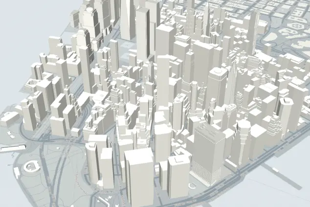
New Yorkers never seem to tire of data maps, and the Downtown Alliance has just released a doozy, with this week's launch of Lower Manhattan 3D, or LM3D. As you can probably guess from the name, the map provides a 3D visualization of the buildings of Lower Manhattan, letting users search by property type (commercial, rental, co-op, condo, hotel, etc.), planned new development, public green space, and more.
The tool is billed as a way to give "planners, investors, residents and all neighborhood stakeholders a new and unparalleled way to visualize the development of this ever evolving neighborhood like never before." (In fairness however, it's actually not the first 3D map of the city; a Japanese artist released a spectacular animated map back in 2015.)
And if you're an actual neighborhood resident, the search filter for "Under Construction" and "Planned Development" might be the most helpful to let you know what new buildings are in the works (and will likely leave you tussling with construction noise in the near future).


And pull up information on individual buildings:

While the map is still technically in beta mode, it's being updated daily and is fully functional. That said, we'd love to see real estate prices added into the mix to paint a clearer picture of the neighborhood economy, though the Alliance for Downtown New York tells us that such a feature likey isn't in the cards.
"In addition to its professional uses—like helping commercial real estate professionals and public policy makers make better informed decisions about the neighborhood—we also see many practical scenarios for the general public," Alliance President Jessica Lappin tells us via email. "One example would be helping a New Yorker identify and evaluate residential properties in Lower Manhattan. The map tracks existing and future properties with daily updates, and from there users can access information on whether the building’s units are for sale or for lease, what retail stores are in the building, and its proximity to subways, hotels, stores and restaurants."
Beyond scoping out new construction, the map seems best implemented as an introduction for out-of-town investors interested in getting an overview of the neighborhood, or curious New Yorkers who just like a good 3D visualization.
You can check out the map's user guide here, play around with the actual map here, and for further research, toggle around the Property Shark air rights map to get more detail on all the new development that's slated for the area.
You Might Also Like


