


Shape-shifting NYC neighborhoods: Why search sites differ on the boundaries, and how it affects your bottom line
This post was updated with additional information on 9/15/16.
Of all the things that are constantly shifting in the world of New York City real estate, you'd at least expect the city's neighborhoods to stay in the same place. But anyone who's spent time searching for an apartment—or simply lived here long enough—can tell you that often, the boundaries of a given neigbhorhood depend heavily on who you're asking.
The size and scope of city neighborhoods do have a way of shifting over time, as new names and subdivisions fall in and out of vogue. "There is a very simple rule to understand neighborhood boundaries," says Mitchell Moss, Henry Hart Rice Professor of Urban Policy at New York University. "Good neighborhoods expand, and bad neighborhoods shrink. And neighborhoods undergoing change try to take on the name of the more attractive adjacent neighbors."
Moreover, says Moss, "Neighborhoods are historic, they evolve and get created all the time, and are also influenced by real estate trends." Oftentimes, New Yorkers themselves will start to carve out neighborhoods for themselves, but the real estate industry is never far behind them.
While the city Department of Planning has its own set neighborhood boundaries that was updated in 2014 (click here to find yours), the waters get more muddied when you start to explore different search portals.
At any given moment, when you try a few different search sites, besides wildly inaccurate attempts at co-opting the glamour of a more popular neighborhood—who hasn't clicked on a "Williamsburg" or "Bushwick" listing, only to see that it's actually in East New York?—you'll find that there isn't necessarily a set agreement on where one neighborhood ends and another begins.
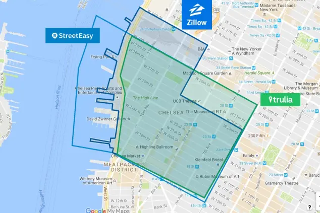
Curious to find out more about this phenomenon, we asked the team at NYC data site NeighborhoodX to compare the borders for some of the more hotly contested NYC neighborhoods to see how they show up on three major search sites: StreetEasy, Zillow, Trulia, and RedFin. And as you can see in the video below, the edges of these neighborhoods seem to fluctuate nearly as much as their rental populations:
Why does this matter, besides as a way to settle that argument with your friend about whether your apartment is really in Astoria or Long Island City? "These boundaries are a starting point for all subsequent analysis, and if that foundation is off, then it casts doubt on the data that's built upon those boundaries," explains NeighborhoodX founder Constantine Valhouli. "For example, the different neighborhood boundaries include and exclude different blocks and buildings. As a result, these can lead to very different results for the 'average' price for a neighborhood, even if everything else is held equal."
Need proof? Check out this chart of the (sometimes huge) differences in average prices that different search portals list for different neighborhoods:

This can also cause potential confusing for buyers who are looking in a certain neighborhood, but need to check multiple sites to make sure they're seeing all the properties that could technically be considered as part of the area. "People who think that they may be buying a property that's identified in Crown Heights by Zillow or StreetEasy [may actually end up] in Bedford-Stuyvesant, according to Trulia," notes Valhouli. "And StreetEasy's neighborhood boundaries place all of Two Bridges—and a portion of the Lower East Side—within Chinatown, while the other sites do not."
None of which is the end of the world if your only concern is, say, your cred as a Lower East Sider. But for a buyer trying to accurately assess comps in a neighborhood (or figure out the eventual resale value of a potential purchase), this lack of clarity can have serious financial ramifications, particularly if the neighborhood in question is directly adjacent to one that's significantly more—or less—desireable to other buyers.
Of course, determining neighborhood borders is a tricky business. For instance, StreetEasy determines its set boundaries "using a mix of sources both official and unofficial," the site's spokesperson Lauren Riefflin tells us. "On the official side, that includes NYC government documentation, like zip code boundaries, community districts, rivers, large avenues, trains, or geographical boundaries. Then we also tap Streeteasy user behavior as well as feedback and widely accepted convention about where certain neighborhoods begin and end. It’s a bit of an art, not a science. But we want to be as relevant and accurate and helpful."
Reifflin notes that while the site does occasionally make changes to their accepted conventions—for instance, recently designating Marble Hill as part of Manhattan, and adding "South Harlem" as a sub-neighborhood of Central Harlem—there are also plenty of suggested updates that they end up nixing, including renaming the Lincoln Square neighborhood as "Columbus Circle," or adding "Rose Hill" as its own Manhattan neighborhood. "As a neighborhood's visibility or popularity increases, we could easily see more requests for revisions. Anecdotally, you can certainly see an uptick in attention to a specific boundary if there’s a lot going on there," Reifflin adds, "But ultimately it all gets put through a rigorous review process, and we require multiple sources if we're going to make a change."
"Neighborhood boundaries tend to be much more subjective than zip code or county lines. Even within neighborhoods, attributes that can affect a home’s value can vary from block to block," Redfin representative Rachel Musiker tells us. For this reason, the company recommends speaking with a local agent with expertise in a given neighborhood to give you a true idea of both lifestyle and prices. To determine the boundaries used on their site, says Musiker, Redfin incorporates agent and customer feedback into its existing data.


You Might Also Like


